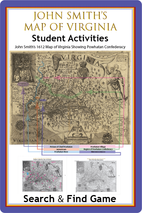
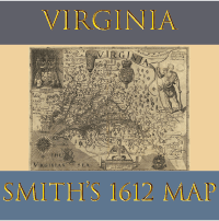
John Smith Virginia Map
Student activities to explore Captain John Smith's 1612 Map of Virginia
Granted, the Jamestown leader didn't know what lay more than 120 miles past the Atlantic coast, and he didn't have the accuracy of modern GPS to make his map. But the map remains signficant for a number of reason.
In the Jamestown & Roanoke Unit Study, students go on the John Smith Virginia Map Scavenger Hunt.
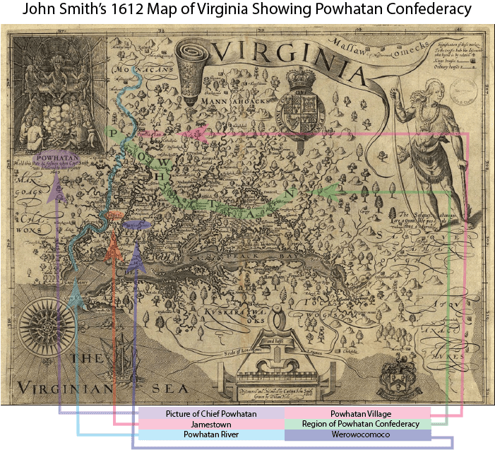
This page provides colored clues and answers.
Note the map's eastern orientation. North is to the right. In this activity students brush up on the map-reading skills. (Turns out that Compass Rose really is important.)
The Name Powhatan
Original is 60 X 78 cm (24 x 31 inches) per Library of Congress. See below under Sources.
Finding Powhatan, Jamestown, and Werowocomoco
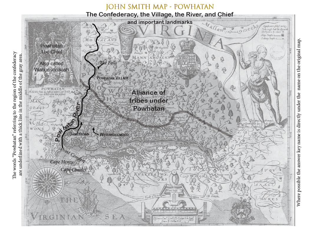
Answer Key above shows the river, the village, the confederacy, and the chieftain with the name "Powhatan."
- Jamestown
- Werowocomoco
- Point Comfort
- Cape Charles
- Cape Henry
Rivers on Smith's 1612 Map of Virginia
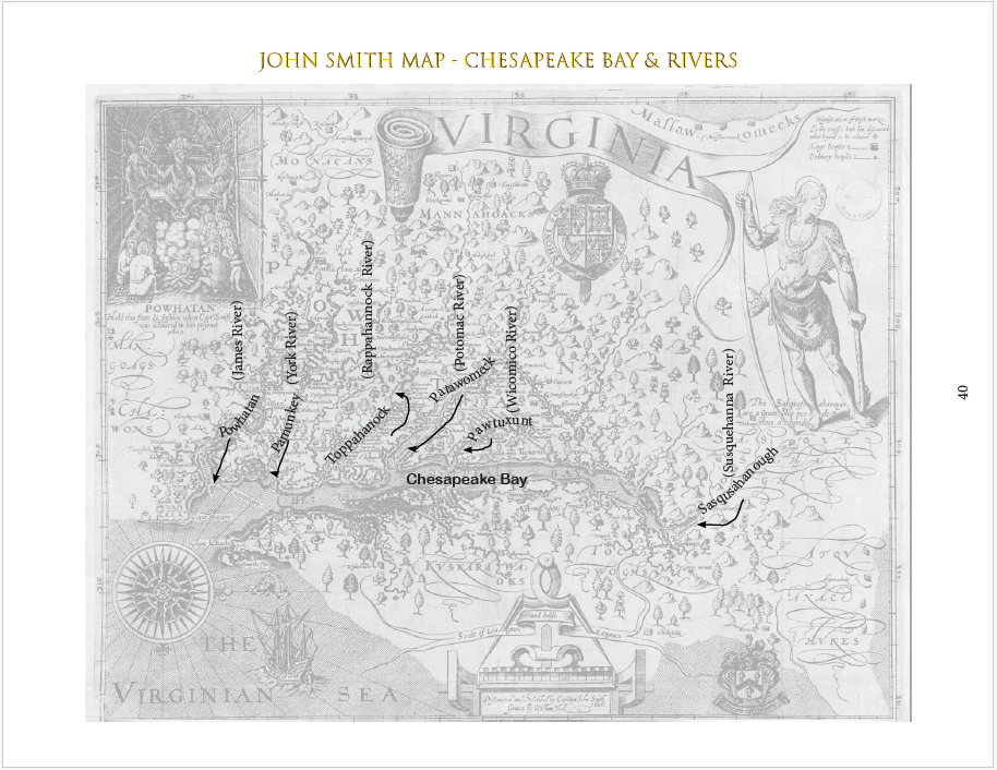
From south to north:
- Powhatan River (James River)
- Pamunkey River (York River)
- Toppahannock River (Rappanhannock River)
- Patawomeck River (Potamac River)
- Pawtuxunt River (Wicomico River)
- Sasqushanough River (Susquahanna River)
Native Tribes
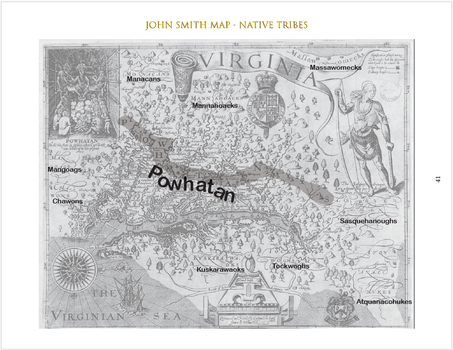
Ten different tribes are identified by region.
Scavenger Hunt: Fun Parts of the Map
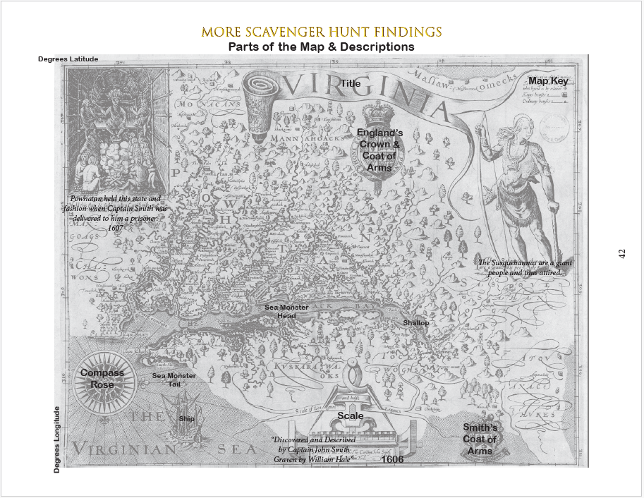
- Map Title (Virginia)
- Scale - Leagues & Half Leagues (League = 3 miles)
- Compass Rose (North is to the right)
- Degrees of Latitude and Longitude
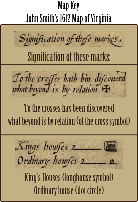
- Compass Key (explains symbols)
- “Discovered and Described by Captain John Smith -Graven by William Hale”
- "Powhatan held this state and fashion when Captain Smith was delivered to him a prisoner."
- 1607 (Smith was captured in December of 1607.)
- "The Susquehannas are a giant people and thus atyred."
- The Year 1606 (That was the year the original three ships left England in December. They arrived April 1607.)
- England’s Coat of Arms and Crown
- Smith’s Coat of Arms with his motto: “To live is to Conquer”
- British Ship (possibly Susan Constant that Smith originally came in)
- Smith’s Shallop (or longboat) for exploring rivers
- and best of all: 2 Sea Monsters (Alternatively, there might be the head and tail of one very, very lo-o-o-ng sea monsther!)
Find the Native Longhouses for Werowances
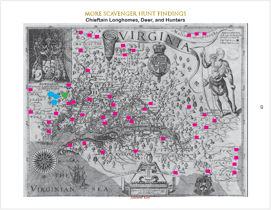
This answer key shows the location of:
- 49 Longhouses
- 3 native hunters with bow
- 2 deer
John Smith's Maltese Cross
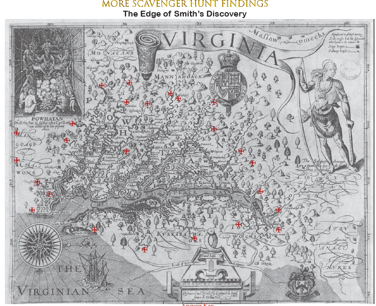
These crosses represent the furthest up a river Smith explored.
Students can cut from cross to cross like a dot-to-dot to better see the area that Smith had explored. Visually, you can see that area as the dense area in the middle. It makes sense he knew more about the tribes and chiefs where he had actually gone. The other information was obtained by natives who indicated what was further ahead up the river.
At www.captainjohnsmith.com you can follow a project to recreate the markers where Smith left his brass crosses and indicated it on his map.
Another question for the astute student: Where else have we seen the Maltese cross employed? (Answer: secret code of Governor John White and the Roanoke settlers.)
Sources for Maps for Teachers/Students
Good news: we provide a copy of the map in our unit study for students to use (as well as 6 answer keys for the teacher.)Bad news: Tiny features are difficult to find on 8.5 x 11 inch paper.
Here are some helps to either buy larger maps or view on-line copies that can be enlarged with your mouse. These were available at the time of this writing. But alas, the internet changes faster than Smith could navigate a river so we don't have live links.
Original: LOC
Smith's map is stored in the Library of Congress:https://www.loc.gov/item/73694565/
Copy and paste the URL address above for a map that can be enlarged on your screen.
Original map is 60 X 78 cm (24 x 31 inches)
Faded Original
Just for the fun of comparison, here is a Library of Congress picture of an old copy, complete with fold marks and wear and tear: https://www.loc.gov/item/73694557/National Park Service: Large Map and Articles
This is a nice sized, visible copy which includes articles about the map and cartography in the 1600's:https://www.nps.gov/articles/000/smith-map-of-virginia.htm
Original Download of Smith's Published Work
This is an online reprint which includes the map and Smith's article about the Virginia landscape:https://www.jstor.org/stable/208424?seq=1
Older Colored Copy
The colored copies are easier to read. Here is an older coloration that can be enlarged on your screen:https://museoteca.com/r/en/work/5778/john_smith/a_map_of_virginia/!/
For Sale: 15 x 13 inches
The teacher that plans ahead can have paper copies on hand! Historic Jamestown sells 15 x 13 maps for only $3.99 (at the time of this writing.)https://historicjamestowne.org/shop/prints-and-postcards/maps/captain-john-smiths-map-of-virginia/
More Options
Check Amazon, Ebay, Museoteca and other sources for map reprints. The day of this writing (2024) I saw a very attractive, 11 x 14 inch, multi-color on white paper reprint on Ebay only $13.95. Larger sizes available (at larger prices naturally.)Get the Early Settlers Unit Study
Available in Paperback OR Printable Download
199 pages (Includes Student Pages, Teacher Key, Schedule, Maps, Activities, and More)
Print It Now
Student and Teacher's Material Included
$5.99 Download - 199 pages
![]()
Softcover Edition - Mailed to You
The same pages are in the softcover book and the printable file. Bound copy is great for repeat use or co-op leaders.

![]()
16.95 Soft Cover Manual
199 pages
Mailed to You
Early Settlers Pages
Check out our other pages for the Early Settlers Unit Study


Get the Lion To Guard Us Unit Study
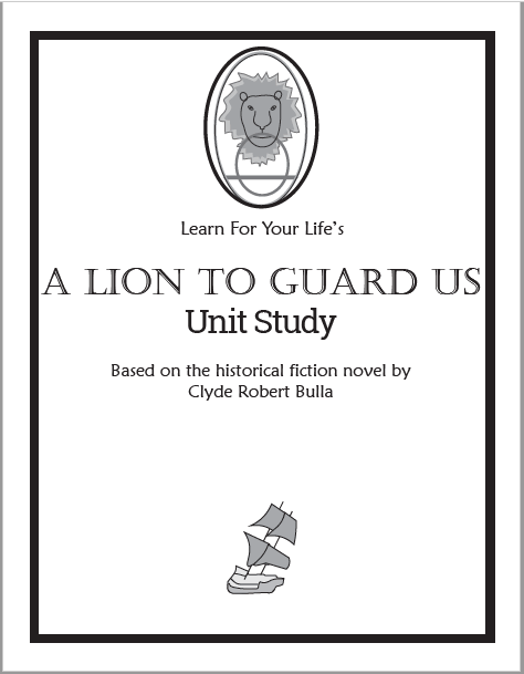
Student Guide AND Teacher's Answer Key Included
$2.99 Download - 78 pages
![]()
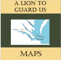
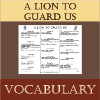
Our pages for A Lion To Guard Us
Clyde Bulla's Historical Fiction of Jamestown & the Sea Venture


Ready To Use Resources


About Our Site
Hands-On Learning