Geography Resources
Our geography resources include fun geography games, geography activities for kids,
and products for teaching geography.
Continents and Oceans Cut Out
Fun Geography Games
Three easy to use geography games for quick and easy review
Begin at Middle Earth
Goal: Identify the countries of the world.
Geography Resources Needed: You will need a globe, either a solid globe or one of the inflatable globes. The solid globes are one of the best scholarly geography resources available. Their inflatable counterparts won't last as long or give as much detail. However, they can be used with numerous games and activities, and you don't lose as much money when a country changes its name.
For this game you can use a blindfold, or have the student close his or her eyes. You will also need a ruler or a piece of an index card that is two inches long and folded in half (as a one inch and two inch marker.)
Students hold an inflatable globe in their hands. Put their fingers in the middle of the Mediterraneum Sea (which means Middle of the World.)
If you have a solid globe on a stand, simply place their finger in the middle of the Mediterraneum.
Announce one of the countries you have studied and that they are reviewing. They have to move their finger from the Mediterraneum to the country.
Three points if they get it right, two points if they are within one inch, and one point if they are within two inches.
Let Your Fingers Do the Walking
Goal: Identify states, provinces, or local regions.
Geography Resources Needed: You will need a map of the United States or other country or region you are studying. You will also need a mask or blind fold for the child(ren).
With the map in front of the blind-folded student, put their index finger on the map of the state or province where you are located.
The student will announce an adjoining state or area and march his/her fingers to that region. Give them the feedback if they are correct (1 point for the name, 1 point for landing on it.) The student can go North, East, West or South.
He or she continues to "visit" other states by announcing a state next to the one they are in.
If they wish to return to their home area, assist them by moving their index finger back to the middle of your state.
They can continue as long as they are able.
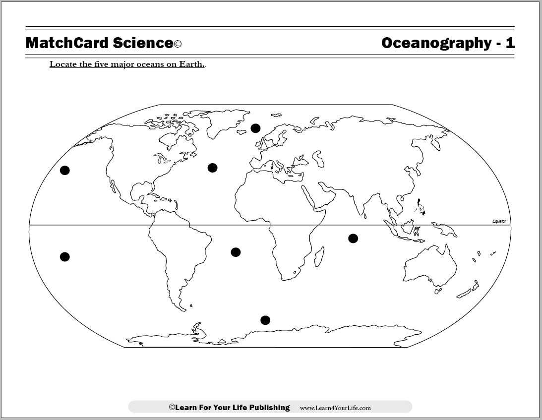
Place the Continents
Goal: Identify continents and oceans.
Geography Resources Needed:For this game, you will need an outline of the world, and cut outs of the 7 continents (or 6 continents, if you leave Europe and Asia together.) Laminated maps are one of the best resources available. One will be cut up into pieces, and the other left whole.
You will also need a mask or blind-fold for the child. The child sits with the whole map of the world in front of him or her.
With the child blindfolded, I hand him or her one of the cut outs of one of the continents. They have to feel the size and shape and guess which continent it is. If they guess correctly, they get one point. If they miss it, simply tell them which continent it is.
Next, they have to place the continent cut out onto the whole world map. They get one point if it touches the correct continent, and two points if 50% of the cut out is on the whole map outline.
Repeat with the other continents.
In addition, you can name the oceans and see if they get put their finger on each of the major oceans.
Our Great Big Earth
3-D Map
Goal: Create a large three dimensional map of your history or geography unit study.
Geography Resources: You will need one of the large exercise balls (preferable one with concentric lines for ease of use.) You will also need a wipe off marker, a permanent marker. A flexible tape measure in centimeters is also helpful. It is also helpful to have a smaller globe (inflatable or solid).
Here's one of the geography resources for the creative student. But please read the warning box at the bottom of the instructions for this activity.
Plan what the globe will represent. For instance, the voyages of the major explorers; the British colonies at the height of England's power; or the location of the world's active volcanoes.
If you use multiple color schemes, the same ball can be used for numerous projects over a year's time.
Here's a suggestion for making it easier to mark on the ball. Use your milimeter ruler to determine the diameter of the ball and the globe. Calculate the difference (It will be mighty handy if the globe happens to be 1/2 the size exactly.)
Using the smaller globe, determine the four outside points of one of the continents. Measure the distance in milimeters from the dead center of the North pole on the small globe. Perform the mathematical calculations for your child (unless this is also a math project for a middle school or older student.) Make dots of the four corners of the continent on the large ball.
Have them trace the outline of the continent on the larger ball with the erasable marker.
Repeat for all other continents.
Once you are satisfied with the results, trace the outline with the permanent marker. (See the warning box, please.)
Then add whatever features are appropriate to your study.
Election Night Returns
Goal: Analyze election results.
Geography Resources: You will need a laminated map of your country, and erasable markers.
As the elction night returns come in, mark the state or province with the results.
For our family in the United States, we use red for Republicans and blue for Democrats as is standard.
Before hand, note how many votes or electoral points are needed for the presidency. As each area announces the results, color it in the appropriate color. Keep a running total of the number of electoral points.
Other benefit: kids who do this once of twice have no trouble understanding what the electoral college is.
We like to make it a super-bowl like party: favorite foods and snacks. Like the Superbowl, we either celebrate or console each other at the end of the night.
Salt Dough Map
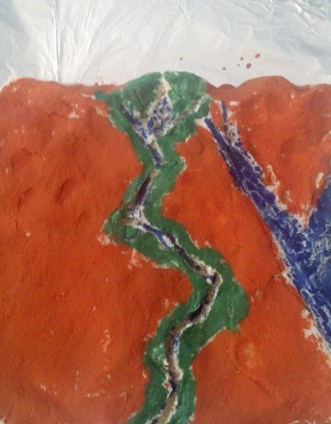
 A simple geography activity for any area you study is a salt dough map. This map to the left shows the Nile River Valley in Egypt, as well as the Sinai Penisula, and the Red Sea.
Salt Dough Recipe:
- One Cup Flour
- Half Cup Salt
- Half Cup Water
Mix the first two ingredients well, then add water. Shape with hands into the desired layout.
Let dry 24 to 48 hours. Then paint.
Geography Resources Needed: You will need a map of the United States or other country or region you are studying. You will also need a mask or blind fold for the child(ren).
With the map in front of the blind-folded student, put their index finger on the map of the state or province where you are located.
The student will announce an adjoining state or area and march his/her fingers to that region. Give them the feedback if they are correct (1 point for the name, 1 point for landing on it.) The student can go North, East, West or South.
He or she continues to "visit" other states by announcing a state next to the one they are in.
If they wish to return to their home area, assist them by moving their index finger back to the middle of your state.
They can continue as long as they are able.
Place the Continents
Goal: Identify continents and oceans.
Geography Resources Needed:For this game, you will need an outline of the world, and cut outs of the 7 continents (or 6 continents, if you leave Europe and Asia together.) Laminated maps are one of the best resources available. One will be cut up into pieces, and the other left whole.
You will also need a mask or blind-fold for the child. The child sits with the whole map of the world in front of him or her.
With the child blindfolded, I hand him or her one of the cut outs of one of the continents. They have to feel the size and shape and guess which continent it is. If they guess correctly, they get one point. If they miss it, simply tell them which continent it is.
Next, they have to place the continent cut out onto the whole world map. They get one point if it touches the correct continent, and two points if 50% of the cut out is on the whole map outline.
Repeat with the other continents.
In addition, you can name the oceans and see if they get put their finger on each of the major oceans.
Our Great Big Earth
3-D Map
Goal: Create a large three dimensional map of your history or geography unit study.
Geography Resources: You will need one of the large exercise balls (preferable one with concentric lines for ease of use.) You will also need a wipe off marker, a permanent marker. A flexible tape measure in centimeters is also helpful. It is also helpful to have a smaller globe (inflatable or solid).
Here's one of the geography resources for the creative student. But please read the warning box at the bottom of the instructions for this activity.
Plan what the globe will represent. For instance, the voyages of the major explorers; the British colonies at the height of England's power; or the location of the world's active volcanoes.
If you use multiple color schemes, the same ball can be used for numerous projects over a year's time.
Here's a suggestion for making it easier to mark on the ball. Use your milimeter ruler to determine the diameter of the ball and the globe. Calculate the difference (It will be mighty handy if the globe happens to be 1/2 the size exactly.)
Using the smaller globe, determine the four outside points of one of the continents. Measure the distance in milimeters from the dead center of the North pole on the small globe. Perform the mathematical calculations for your child (unless this is also a math project for a middle school or older student.) Make dots of the four corners of the continent on the large ball.
Have them trace the outline of the continent on the larger ball with the erasable marker.
Repeat for all other continents.
Once you are satisfied with the results, trace the outline with the permanent marker. (See the warning box, please.)
Then add whatever features are appropriate to your study.
Election Night Returns
Goal: Analyze election results.
Geography Resources: You will need a laminated map of your country, and erasable markers.
As the elction night returns come in, mark the state or province with the results.
For our family in the United States, we use red for Republicans and blue for Democrats as is standard.
Before hand, note how many votes or electoral points are needed for the presidency. As each area announces the results, color it in the appropriate color. Keep a running total of the number of electoral points.
Other benefit: kids who do this once of twice have no trouble understanding what the electoral college is.
We like to make it a super-bowl like party: favorite foods and snacks. Like the Superbowl, we either celebrate or console each other at the end of the night.
Salt Dough Map
A simple geography activity for any area you study is a salt dough map. This map to the left shows the Nile River Valley in Egypt, as well as the Sinai Penisula, and the Red Sea.
Salt Dough Recipe:
- One Cup Flour
- Half Cup Salt
- Half Cup Water
Mix the first two ingredients well, then add water. Shape with hands into the desired layout.
Let dry 24 to 48 hours. Then paint.

Ready To Use Resources
About Our Site
Hands-On Learning